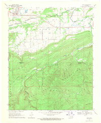
1969 Map of Kinta
USGS Topo · Published 1971About this map
The town of Kinta serves as the focal point for this survey, situated at the junction of the plains and the rising peaks of the Sans Bois Mountains. By the late 1960s, the local economy was defined by a heavy reliance on natural resources, evidenced by the numerous Gas Well sites and extensive Strip Mine operations scattered across the lowlands. The landscape transitions from the agricultural and industrial flats near Beaver Creek and Sans Bois Creek to the sharp elevation of Vaughn Hollow Mountain in the south, which marks the boundary between Haskell and Latimer Counties.
Find a feature on this map
26 named features on this map. Tap any name to fly to it.
Don’t see what you’re looking for? This feature index may not catch every label — zoom into the map to look around manually.
Map Details
Editions of this 1969 Kinta Map
2 editions found
Other maps of this area

1900 · Sansbois
USGS Topo · 1:125,000

1901 · Tuskahoma
USGS Topo · 1:125,000

1908 · Tuskahoma
USGS Topo · 1:125,000

1909 · Tuskahoma
USGS Topo · 1:125,000

1909 · Sans Bois
USGS Topo · 1:125,000

1911 · Sansbois
USGS Topo · 1:125,000

1940 · Red Oak
USGS Topo · 1:62,500

1943 · Red Oak
USGS Topo · 1:62,500

1946 · Fort Smith
USGS Topo · 1:250,000

1950 · Mcalester
USGS Topo · 1:250,000