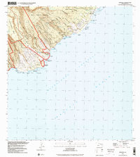
1995 Map of Kipahulu
USGS Topo · Published 2002About this map
Kipahulu and the surrounding coastline of the Hāna District occupy this late-twentieth-century study, where the steep transitions from the volcanic interior meet the Alenuihāhā Channel. The settlement patterns here are defined by deep coastal gulches such as Pukulua Gulch and Pōhakunāhala Gulch, with small communities like Wailua and Koali linked by a winding perimeter road. Evidence of historical land use and preservation is clear in the Waiohonu-Kaki'o Homesteads and the sprawling Hana Forest Reserve. Along the shoreline, landmark features like the Seven Pools and a historical monument near the Kipahulu coast reflect the intersection of traditional landscape and managed parkland within the Haleakalā National Park boundaries. Several cemeteries and water tanks are noted, providing specific points of interest for genealogists tracing family locations near the old landing.
Find a feature on this map
86 named features on this map. Tap any name to fly to it.
Don’t see what you’re looking for? This feature index may not catch every label — zoom into the map to look around manually.
Map Details
Editions of this 1995 Kipahulu Map
This is the sole edition of this map. No revisions or reprints were ever made.
Other maps of this area

1954 · Maui
USGS Topo · 1:250,000

1957 · Kipahulu
USGS Topo · 1:24,000

1957 · Hana
USGS Topo · 1:24,000

1957 · Nahiku
USGS Topo · 1:24,000

1957 · Kaupo
USGS Topo · 1:24,000

1966 · Maui
USGS Topo · 1:250,000

1974 · Maui
USGS Topo · 1:250,000

1978 · Hana
USGS Topo · 1:24,000

1983 · Nahiku
USGS Topo · 1:24,000
1983 · Kaupo
USGS Topo · 1:24,000