
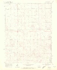
1969 Map of Kirk
USGS Topo · Published 1972About this map
Kirk sits at a high-plains crossroads on the border of Yuma and Kit Carson counties, anchoring a landscape shaped by the drainage of the South Fork Republican River. Surveyed in the late 1960s, this area reflects the agricultural and recreational priorities of the eastern Colorado plains, where the Royce Darling Memorial Golf Course and Idler Landing Strip provide notable social and logistical hubs for the surrounding farmsteads. The terrain is defined by dry washes and intermittent streams like Hell Creek and Spring Creek, which carve subtle topography into the otherwise level horizon. Genealogists will find the Kirk Cemetery located south of the main settlement, while industrial activity is limited to local resources such as the Gravel Pit near the river fork. This map captures the region before modern irrigation and land-use shifts further altered the high-desert character of the Republican River valley.
Find a feature on this map
9 named features on this map. Tap any name to fly to it.
Don’t see what you’re looking for? This feature index may not catch every label — zoom into the map to look around manually.
Map Details
Editions of this 1969 Kirk Map
2 editions found
Other maps of this area

1954 · Limon
USGS Topo · 1:250,000

1957 · Limon
USGS Topo · 1:250,000

1958 · Limon
USGS Topo · 1:250,000

1968 · Joes
USGS Topo · 1:24,000

1968 · Spring Canyon
USGS Topo · 1:24,000

1968 · Adler Creek
USGS Topo · 1:24,000

1969 · Settlement
USGS Topo · 1:24,000

1969 · Tuttle
USGS Topo · 1:24,000

1969 · Idalia SW
USGS Topo · 1:24,000
1978 · Joes SW
USGS Topo · 1:24,000