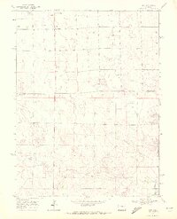
1969 Map of Kirk
USGS Topo · Published 1972About this map
Kirk serves as the central hub of this eastern Colorado landscape, situated near the northern edge of the survey area. The terrain is defined by the drainage systems of the South Fork Republican River and its tributaries, including Hell Creek and Spring Creek, which carve subtle depressions through the plains. Local infrastructure in the late 1960s includes the Idler Landing Strip and the Royce Darling Memorial Golf Course, reflecting the community's recreational and transportation needs. For genealogists, the Kirk Cem provides a specific point of interest just south of the town site. The map also delineates the boundary between Yuma County and Kit Carson County, showing the agricultural and ranching patterns that dominate the region through numerous marked wells and section-line roads.
Find a feature on this map
10 named features on this map. Tap any name to fly to it.
Don’t see what you’re looking for? This feature index may not catch every label — zoom into the map to look around manually.
Map Details
Editions of this 1969 Kirk Map
2 editions found
Other maps of this area

1954 · Limon
USGS Topo · 1:250,000

1957 · Limon
USGS Topo · 1:250,000

1958 · Limon
USGS Topo · 1:250,000

1968 · Joes
USGS Topo · 1:24,000

1968 · Spring Canyon
USGS Topo · 1:24,000

1968 · Adler Creek
USGS Topo · 1:24,000

1969 · Settlement
USGS Topo · 1:24,000

1969 · Tuttle
USGS Topo · 1:24,000

1969 · Idalia SW
USGS Topo · 1:24,000

1969 · Kirk
USGS Topo · 1:24,000