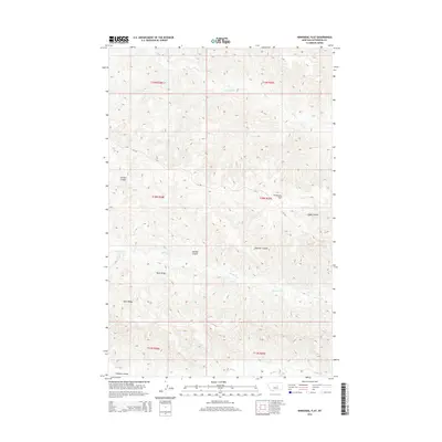
2014 Map of Kirkendal Flat
USGS Topo · Published 2014About this map
Kirkendal Flat and the surrounding rangeland of Petroleum County define this landscape of high ridges and deep drainage channels. The area is characterized by a series of prominent coulees, including Gordon Coulee, Gibbs Coulee, and Kastner Coulee, which cut through the terrain toward more significant water bodies. These seasonal and perennial flows, such as Dovetail Cr and Blood Cr, follow the natural contours of the land, illustrating the complex hydrologic network of the Missouri River basin. Modern infrastructure is minimal in this portion of the Montana plains, represented primarily by the 79 Trl route. The map documents the vastness of Dunn Ridge, a topographical anchor that separates the various coulee systems, providing a clear picture of the land's structural geology and natural drainage patterns near the start of the 21st century.
Find a feature on this map
16 named features on this map. Tap any name to fly to it.
Don’t see what you’re looking for? This feature index may not catch every label — zoom into the map to look around manually.
Map Details
Editions of this 2014 Kirkendal Flat Map
This is the sole edition of this map. No revisions or reprints were ever made.
Other maps of this area

1954 · Jordan
USGS Topo · 1:250,000

1954 · Lewistown
USGS Topo · 1:250,000

1956 · Jordan
USGS Topo · 1:250,000

1958 · Jordan
USGS Topo · 1:250,000

1959 · Lewistown
USGS Topo · 1:250,000

1964 · Jordan
USGS Topo · 1:250,000

1965 · Germaine Coulee West
USGS Topo · 1:24,000
1965 · Weingart Place
USGS Topo · 1:24,000

1965 · Weingart Place NW
USGS Topo · 1:24,000

1967 · Nelson Coulee
USGS Topo · 1:24,000