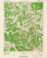
1953 Map of Kirkmansville
USGS Topo · Published 1966About this map
Kirkmansville and the small crossroads of Weir anchor this study of the western Kentucky borderlands during the early 1950s. The landscape is defined by the winding course of the Pond River and its numerous tributaries, including Long Creek and Caney Creek. The map reveals a deeply settled rural interior where community life centered around small schools like Weir Sch and Everett Sch, and a notable density of country churches such as Greenbrier Ch and Lone Star Ch.
Find a feature on this map
52 named features on this map. Tap any name to fly to it.
Don’t see what you’re looking for? This feature index may not catch every label — zoom into the map to look around manually.
Map Details
Editions of this 1953 Kirkmansville Map
2 editions found
Other maps of this area

1911 · Drakesboro
USGS Topo · 1:48,000

1912 · Nortonville
USGS Topo · 1:62,500

1913 · Drakesboro
USGS Topo · 1:62,500

1952 · Sharon Grove
USGS Topo · 1:24,000

1952 · Allegre
USGS Topo · 1:24,000

1952 · Honey Grove
USGS Topo · 1:24,000

1952 · Greenville
USGS Topo · 1:24,000

1953 · Drakesboro
USGS Topo · 1:24,000

1953 · Haleys Mill
USGS Topo · 1:24,000

1953 · Rosewood
USGS Topo · 1:24,000