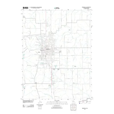
2012 Map of Kirksville
USGS Topo · Published 2012About this map
Kirksville stands as a significant educational and residential hub in Adair County, defined by the campuses of Truman State University and the historic Kirksville College of Osteopathic Medicine. The landscape is a mix of dense municipal development and surrounding water systems, including Bear Creek, Steer Creek, and the East Fork Little Chariton River to the south. Numerous cemeteries, such as Forest-Llewellyn Cemetery and Bear Creek Cemetery, provide valuable anchor points for genealogical research, while the western edge is dominated by the recreational expanse of Thousand Hills State Park and Forest Lake. To the south, the small settlement of Troy Mills appears near the banks of Sugar Creek. The area's hydrology is further detailed by several engineered structures like Denslow Lake Dam and Sam Burk Dam, illustrating how the local geography has been managed to support the growing community and its institutions.
Find a feature on this map
100 named features on this map. Tap any name to fly to it.
Don’t see what you’re looking for? This feature index may not catch every label — zoom into the map to look around manually.
Map Details
Editions of this 2012 Kirksville Map
This is the sole edition of this map. No revisions or reprints were ever made.
Other maps of this area

1903 · Edina
USGS Topo · 1:125,000

1911 · Queen City
USGS Topo · 1:62,500

1913 · Queen City
USGS Topo · 1:62,500

1938 · Kirksville
USGS Topo · 1:62,500

1940 · Kirksville
USGS Topo · 1:62,500

1954 · Centerville
USGS Topo · 1:250,000

1957 · Centerville
USGS Topo · 1:250,000

1958 · Centerville
USGS Topo · 1:250,000

1966 · Brashear
USGS Topo · 1:24,000
1966 · Willmathsville
USGS Topo · 1:24,000