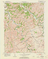
1952 Map of Kirksville
USGS Topo · Published 1973About this map
Poosey Ridge dominates the upland geography between the meandering courses of Paint Lick Creek and Silver Creek, marking a landscape defined by sharp ridges and deep hollows along the Madison and Garrard County line. During the early 1950s, this region was a network of rural settlements and family-named landmarks connected by winding ridge roads. The presence of numerous local institutions, such as Salem Ch, Beech Grove Ch, and Kirksville Sch, illustrates a community-focused interior where schools and churches served as the primary hubs for scattered farmsteads. Smaller hamlets like Cottonburg, Gilead, and Nina are visible, while the eponymous Kirksville stands as a central point of commerce. Genealogists will find particular value in the detailed placement of family burying grounds, including Sebastian Cem, Coy Cem, and Wheeler Cem, which are often difficult to locate in modern contexts.
Find a feature on this map
48 named features on this map. Tap any name to fly to it.
Don’t see what you’re looking for? This feature index may not catch every label — zoom into the map to look around manually.
Map Details
Editions of this 1952 Kirksville Map
3 editions found
Other maps of this area

1892 · Richmond
USGS Topo · 1:125,000

1897 · Richmond
USGS Topo · 1:125,000

1905 · Harrodsburg
USGS Topo · 1:125,000

1952 · Berea
USGS Topo · 1:24,000

1952 · Valley View
USGS Topo · 1:24,000

1952 · Little Hickman
USGS Topo · 1:24,000

1952 · Buckeye
USGS Topo · 1:24,000

1952 · Paint Lick
USGS Topo · 1:24,000

1952 · Lancaster
USGS Topo · 1:24,000

1952 · Kirksville
USGS Topo · 1:24,000