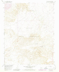
1966 Map of Kirtland SW
USGS Topo · Published 1980About this map
The Navajo Indian Reservation dominates this 1960s landscape in San Juan County, showcasing a terrain defined by desert drainage patterns and emerging industrial infrastructure. Water management is central to the area's utility, marked by the presence of Cottonwood Springs and various Water Tanks positioned near the rugged Cottonwood Arroyo. A notable Pipeline cuts across the northern half of the quadrangle, signaling the region's role in energy transport during the mid-century period. The map records the early stages of resource extraction with several identified Drill Holes and a Gas Well located near the eastern boundary. The intricate topography near Chinde Wash illustrates the erosive power of seasonal water flow in this arid environment, providing a detailed look at the land's character before later modern developments changed the local footprint.
Find a feature on this map
12 named features on this map. Tap any name to fly to it.
Don’t see what you’re looking for? This feature index may not catch every label — zoom into the map to look around manually.
Map Details
Editions of this 1966 Kirtland SW Map
2 editions found
Other maps of this area

1889 · Chaco
USGS Topo · 1:250,000

1892 · Chaco
USGS Topo · 1:250,000

1927 · Sulphur Spring
USGS Topo · 1:96,000

1928 · Kirtland
USGS Topo · 1:125,000

1932 · Kirtland
USGS Topo · 1:125,000

1954 · Shiprock
USGS Topo · 1:250,000

1958 · Shiprock
USGS Topo · 1:250,000

1959 · Shiprock
USGS Topo · 1:250,000
1966 · The Hogback North
USGS Topo · 1:24,000
1966 · Newcomb NE
USGS Topo · 1:24,000