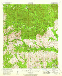
1954 Map of Kisatchie
USGS Topo · Published 1958About this map
Kisatchie National Forest dominates this mid-1950s landscape, where the dense timberlands are carved by deep bayous and military activity. To the west, the Fort Polk Military Reservation and Peason Ridge Artillery Range occupy significant acreage, bordering settlements like Kurthwood and Mink. The map documents a period when the timber industry's older infrastructure was fading, evidenced by a dismantled railroad snaking through the hills near Hutton and Simpson.
Find a feature on this map
53 named features on this map. Tap any name to fly to it.
Don’t see what you’re looking for? This feature index may not catch every label — zoom into the map to look around manually.
Map Details
Editions of this 1954 Kisatchie Map
3 editions found
Other maps of this area

1937 · Chopin SW
USGS Topo · 1:31,680

1937 · Chopin NW
USGS Topo · 1:31,680

1937 · Bellwood
USGS Topo · 1:31,680

1937 · Montgomery
USGS Topo · 1:62,500

1937 · Cloutierville
USGS Topo · 1:31,680

1937 · Cypress
USGS Topo · 1:31,680

1941 · Leesville
USGS Topo · 1:62,500

1941 · Slagle
USGS Topo · 1:62,500

1942 · Many
USGS Topo · 1:62,500

1942 · Florien
USGS Topo · 1:62,500