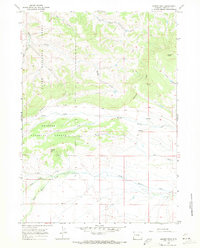
1967 Map of Kismet Peak
USGS Topo · Published 1971About this map
Kismet Peak rises above a high-altitude wilderness where the northern boundary of the Bridger National Forest meets the southern reaches of the Teton National Forest. This 1967 field-checked survey documents a landscape defined by an intricate network of drainage systems feeding into the Beaver Creek watershed. The central terrain is carved by the North Fork, Middle Beaver Creek, and South Fork Beaver Creek, alongside prominent geographic markers like Tripod Hill and the South Rim. Sparse development is evidenced by the presence of a lone Jeep Trail winding through the northern sections near South Fork Fisherman Creek. The map captures the area just before significant modern shifts in forest management, preserving the location of unnamed springs and seasonal drainages like Cow Gulch and Annie Draw that are essential to understanding the hydrology of this high Wyoming plateau.
Find a feature on this map
21 named features on this map. Tap any name to fly to it.
Don’t see what you’re looking for? This feature index may not catch every label — zoom into the map to look around manually.
Map Details
Editions of this 1967 Kismet Peak Map
This is the sole edition of this map. No revisions or reprints were ever made.
Other maps of this area

1907 · Gros Ventre
USGS Topo · 1:125,000

1910 · Gros Ventre
USGS Topo · 1:125,000

1939 · Big Piney
USGS Topo · 1:125,000

1942 · Big Piney
USGS Topo · 1:125,000

1955 · Driggs
USGS Topo · 1:250,000

1955 · Preston
USGS Topo · 1:250,000

1958 · Driggs
USGS Topo · 1:250,000

1958 · Preston
USGS Topo · 1:250,000

1962 · Driggs
USGS Topo · 1:250,000

1962 · Preston
USGS Topo · 1:250,000