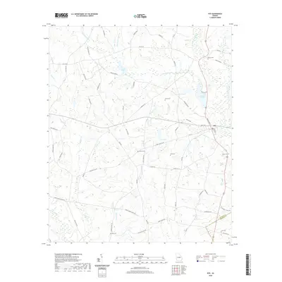
2020 Map of Kite
USGS Topo · Published 2020About this map
The town of Kite sits near the eastern edge of Johnson County, where the landscape is defined by the winding paths of the Little Ohoopee River and Ohoopee River. This 2020 survey illustrates a rural Georgia community where family-named roads and landmarks remain central to the local identity. The terrain is a network of creek drainages including Big Battleground Cr, Neels Cr, and Mulepen Cr, which feed into various small impoundments such as Josey Pond, Meeks Pond, and Rayonair Pond. For genealogists and local historians, the map provides precise locations for several community burial grounds, including Gum Log Cem and Fortner Cem. The southern boundary is marked by the Johnson Co Emanuel Co line, showing the settlement's relationship to the neighboring county through a series of local connectors like Midas Brantley Rd and Meeks Rd.
Find a feature on this map
73 named features on this map. Tap any name to fly to it.
Don’t see what you’re looking for? This feature index may not catch every label — zoom into the map to look around manually.
Map Details
Editions of this 2020 Kite Map
This is the sole edition of this map. No revisions or reprints were ever made.
Other maps of this area

1957 · Macon
USGS Topo · 1:250,000

1958 · Macon
USGS Topo · 1:250,000

1964 · Macon
USGS Topo · 1:250,000

1971 · Norristown
USGS Topo · 1:24,000

1971 · Dellwood
USGS Topo · 1:24,000
1973 · Davisboro SE
USGS Topo · 1:24,000
1973 · Harrison
USGS Topo · 1:24,000
1973 · Wadley
USGS Topo · 1:24,000

1974 · Kite
USGS Topo · 1:24,000

1974 · Wrightsville
USGS Topo · 1:24,000