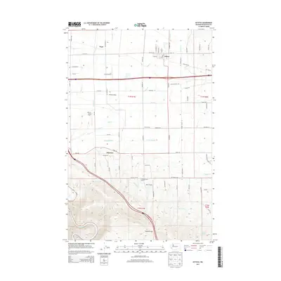
2013 Map of Kittitas
USGS Topo · Published 2013About this map
The town of Kittitas serves as the hub of this agricultural landscape in the central portion of the Kittitas Valley. The terrain transitions from the irrigated flats of the valley floor to the rising slopes of Vanderbilt Gap in the south, where the Yakima River cuts through the corner of the survey. The map reveals an intricate network of water management features essential to local farming, including the Wipple Wasteway, Turbine Ditch, and Pump Ditch. Numerous private landing strips, such as D Farms Airport, Hillcrest Farms Airport, and Beiter Airport, are scattered among the farmsteads, reflecting the large-scale aerial needs of modern ranching and agriculture. The small settlement of Regal and the landmark Denmark Hall provide further points of reference within this rural grid of numbered roads and irrigation canals.
Find a feature on this map
108 named features on this map. Tap any name to fly to it.
Don’t see what you’re looking for? This feature index may not catch every label — zoom into the map to look around manually.
Map Details
Editions of this 2013 Kittitas Map
This is the sole edition of this map. No revisions or reprints were ever made.
Other maps of this area

1897 · Mount Stuart
USGS Topo · 1:125,000

1899 · Ellensburg
USGS Topo · 1:125,000

1901 · Ellensburg
USGS Topo · 1:125,000

1902 · Mount Stuart
USGS Topo · 1:125,000

1920 · Colockum Pass
USGS Topo · 1:125,000

1922 · Colockum Pass
USGS Topo · 1:125,000

1938 · Badger Pocket
USGS Topo · 1:48,000

1943 · Badger Pocket
USGS Topo · 1:62,500

1950 · Yakima
USGS Topo · 1:250,000
1953 · Badger Gap
USGS Topo · 1:24,000