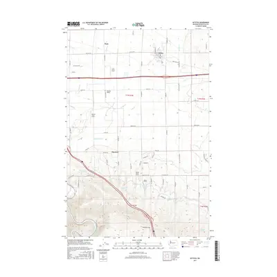
2017 Map of Kittitas
USGS Topo · Published 2017About this map
The town of Kittitas sits at the heart of this agricultural landscape, where an intricate network of irrigation ditches and creeks supports the Kittitas Valley economy. Water management is a defining characteristic of the terrain, visible in the engineered pathways of the Wipple Wasteway, Bull Ditch, and Turbine Ditch. These systems crisscross the plains between smaller settlements like Regal and Edgemont, facilitating a high density of local aviation with several private airfields such as JKD Farms Airport and Hillcrest Farms Airport serving the surrounding farms.
Find a feature on this map
77 named features on this map. Tap any name to fly to it.
Don’t see what you’re looking for? This feature index may not catch every label — zoom into the map to look around manually.
Map Details
Editions of this 2017 Kittitas Map
This is the sole edition of this map. No revisions or reprints were ever made.
Other maps of this area

1897 · Mount Stuart
USGS Topo · 1:125,000

1899 · Ellensburg
USGS Topo · 1:125,000

1901 · Ellensburg
USGS Topo · 1:125,000

1902 · Mount Stuart
USGS Topo · 1:125,000

1920 · Colockum Pass
USGS Topo · 1:125,000

1922 · Colockum Pass
USGS Topo · 1:125,000

1938 · Badger Pocket
USGS Topo · 1:48,000

1943 · Badger Pocket
USGS Topo · 1:62,500

1950 · Yakima
USGS Topo · 1:250,000
1953 · Badger Gap
USGS Topo · 1:24,000