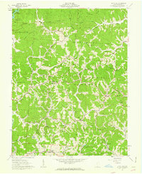
1961 Map of Kitts Hill
USGS Topo · Published 1963About this map
The Wayne National Forest covers the ridges and hollows of this part of southern Ohio in the early 1960s, a landscape defined by small ridgetop settlements and deep creek valleys. In Kitts Hill, the rural community is anchored by churches and schools such as Mamre Ch and Rock Hill Sch. To the northwest, the Vesuvius Recreation Area centers on Lake Vesuvius, which provided a significant public landscape for the region following its development by the Civilian Conservation Corps in the previous decades. The map records numerous family-named landmarks and cemeteries, including the Currington Cem and Bazell Cem near Rock Camp. Numerous Mines and a Pipeline are printed across the hills, marking the intersection of the region's extractive industrial history with its developing parklands and rural farmsteads.
Find a feature on this map
85 named features on this map. Tap any name to fly to it.
Don’t see what you’re looking for? This feature index may not catch every label — zoom into the map to look around manually.
Map Details
Editions of this 1961 Kitts Hill Map
This is the sole edition of this map. No revisions or reprints were ever made.
Other maps of this area

1892 · Huntington
USGS Topo · 1:125,000

1898 · Huntington
USGS Topo · 1:125,000

1898 · Ironton
USGS Topo · 1:62,500

1900 · Ironton
USGS Topo · 1:62,500

1901 · Guyandot
USGS Topo · 1:62,500

1901 · Ceredo
USGS Topo · 1:62,500

1902 · Guyandot
USGS Topo · 1:62,500

1903 · Kenova
USGS Topo · 1:125,000

1904 · Kenova
USGS Topo · 1:125,000

1906 · Athalia
USGS Topo · 1:62,500