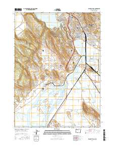
2017 Map of Klamath Falls
USGS Topo · Published 2017About this map
Klamath Falls sits at the nexus of a complex hydrological landscape where Upper Klamath Lake empties into the Link River, passing through the center of the city toward Lake Ewauna. The industrial and agricultural heritage of the region is written into the terrain through extensive water management systems, including the A Canal, Plevna Ditch, and the Lost River Diversion Channel. South of the urban center, the land transitions into the expansive Wocus Marsh and the reclaimed agricultural tracts of Miller Island and the Spring Lake Valley. Local genealogists can locate several significant burial grounds, such as Linkville Cem and Klamath Memorial Park, while those interested in local infrastructure can trace the path of the BNSF Railway as it services the outlying communities of Midland and Falcon Heights. The map also reveals specialized landmarks like Stonehenge and the Fremont Bridge spanning the river narrows.
Find a feature on this map
148 named features on this map. Tap any name to fly to it.
Don’t see what you’re looking for? This feature index may not catch every label — zoom into the map to look around manually.
Map Details
Editions of this 2017 Klamath Falls Map
This is the sole edition of this map. No revisions or reprints were ever made.
Other maps of this area

1889 · Klamath
USGS Topo · 1:250,000

1894 · Klamath
USGS Topo · 1:250,000

1955 · Klamath Falls
USGS Topo · 1:250,000

1957 · Merrill
USGS Topo · 1:62,500

1957 · Swan Lake
USGS Topo · 1:62,500

1957 · Klamath Falls
USGS Topo · 1:62,500

1957 · Modoc Point
USGS Topo · 1:62,500

1958 · Klamath Falls
USGS Topo · 1:250,000
1975 · Klamath Falls NE
USGS Topo · 1:24,000

1975 · Merrill NW
USGS Topo · 1:24,000