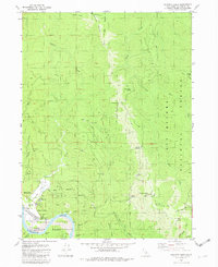
1982 Map of Klamath Glen
USGS Topo · Published 1982About this map
The Klamath River carves a deep valley through the northern California landscape, forming a natural boundary for the Hoopa Valley Indian Reservation in this 1982 survey. The settlement of Klamath Glen serves as a focal point near the riverbank, featuring a Boat Ramp, Pumping Sta, and multiple Trailer Park areas that suggest a community oriented toward the water and seasonal recreation. High above the valley floor, the Six Rivers National Forest covers the eastern ridges, where Red Mountain is topped by a Lookout Tower and Radio Facilities.
Find a feature on this map
45 named features on this map. Tap any name to fly to it.
Don’t see what you’re looking for? This feature index may not catch every label — zoom into the map to look around manually.
Map Details
Editions of this 1982 Klamath Glen Map
2 editions found
Other maps of this area

1922 · Preston Peak
USGS Topo · 1:125,000

1925 · Hoopa
USGS Topo · 1:125,000

1929 · Crescent City
USGS Topo · 1:125,000

1945 · Ship Mountain
USGS Topo · 1:62,500

1945 · Orick
USGS Topo · 1:62,500

1945 · Requa
USGS Topo · 1:62,500

1945 · Tectah Creek
USGS Topo · 1:62,500

1948 · Weed
USGS Topo · 1:250,000

1949 · Eureka
USGS Topo · 1:250,000

1950 · Weed
USGS Topo · 1:250,000