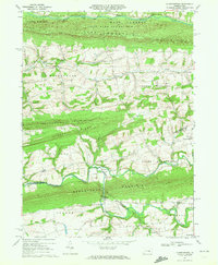
1969 Map of Klingerstown
USGS Topo · Published 1972About this map
Line Mountain and Mahantango Mountain define the parallel ridgelines of this central Pennsylvania landscape, where narrow valleys have fostered a series of isolated rural settlements. The drainage patterns of Mahanoy Creek to the north and Mahantango Creek through the center dictate the local topography, which is dotted with numerous small country churches like Himmels Ch and St Johns Ch. This late-1960s survey documents the traditional community clusters of Rebuck, Leck Kill, and the evocatively named Rough and Ready.
Find a feature on this map
45 named features on this map. Tap any name to fly to it.
Don’t see what you’re looking for? This feature index may not catch every label — zoom into the map to look around manually.
Map Details
Editions of this 1969 Klingerstown Map
3 editions found
Other maps of this area

1892 · Lykens
USGS Topo · 1:62,500

1892 · Shamokin
USGS Topo · 1:62,500

1893 · Sunbury
USGS Topo · 1:62,500

1893 · Lykens
USGS Topo · 1:62,500

1893 · Shamokin
USGS Topo · 1:62,500

1893 · Millersburg
USGS Topo · 1:62,500

1943 · Millersburg
USGS Topo · 1:62,500

1943 · Lykens
USGS Topo · 1:62,500

1943 · Shamokin
USGS Topo · 1:62,500

1943 · Sunbury
USGS Topo · 1:62,500
Featured Places
- West Cameron Township, PA
- Hubley Township, PA
- Lykens Township, PA
- Little Mahanoy Township, PA
- Hebe, Jordan Township