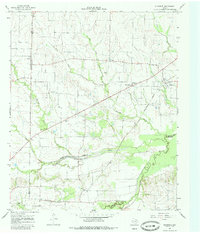
1964 Map of Klondike
USGS Topo · Published 1985About this map
The Southern Pacific railroad cuts a diagonal line across this 1964 landscape, anchoring the community of Klondike and connecting it to smaller rail-side settlements like Horton. This survey captures a rural Texas transition where traditional farming communities such as Yowell, Gough, and Needmore were defined by local landmarks like Wintermute Mem Hosp and the Roadside Park near Pecan Creek.
Find a feature on this map
23 named features on this map. Tap any name to fly to it.
Don’t see what you’re looking for? This feature index may not catch every label — zoom into the map to look around manually.
Map Details
Editions of this 1964 Klondike Map
2 editions found
Other maps of this area

1953 · Texarkana
USGS Topo · 1:250,000

1956 · Texarkana
USGS Topo · 1:250,000

1964 · Cumby
USGS Topo · 1:24,000

1964 · Commerce South
USGS Topo · 1:24,000

1964 · Gafford Chapel
USGS Topo · 1:24,000

1964 · Klondike
USGS Topo · 1:24,000

1964 · Commerce North
USGS Topo · 1:24,000

1964 · Cooper North
USGS Topo · 1:24,000

1964 · Ladonia
USGS Topo · 1:24,000

1964 · Pecan Gap
USGS Topo · 1:24,000