
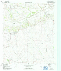
1964 Map of Pecan Gap
USGS Topo · Published 1968About this map
Pecan Gap serves as a central hub on this mid-century survey, situated at the intersection of the Atchison Topeka and Santa Fe railroad and several regional roads. The landscape is defined by the winding course of the North Sulphur River, which carves through the northern portion of the quadrangle. Numerous small cemeteries, such as Whittenburg Cem and Giles Cem, are scattered across the rural acreage, indicating a pattern of family homesteads and small-scale agriculture.
Find a feature on this map
34 named features on this map. Tap any name to fly to it.
Don’t see what you’re looking for? This feature index may not catch every label — zoom into the map to look around manually.
Map Details
Editions of this 1964 Pecan Gap Map
2 editions found
Other maps of this area

1903 · Paris
USGS Topo · 1:125,000

1947 · Honey Grove
USGS Topo · 1:62,500

1948 · Paris
USGS Topo · 1:62,500

1949 · Honey Grove
USGS Topo · 1:62,500

1949 · Paris
USGS Topo · 1:62,500

1953 · Texarkana
USGS Topo · 1:250,000

1956 · Texarkana
USGS Topo · 1:250,000

1964 · Klondike
USGS Topo · 1:24,000

1964 · Commerce North
USGS Topo · 1:24,000

1964 · Cooper North
USGS Topo · 1:24,000