
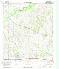
1964 Map of Cumby
USGS Topo · Published 1968About this map
Cumby serves as a primary hub in this mid-1960s landscape, situated at the intersection of vital transport lines including the Louisiana and Arkansas roadway. The surrounding countryside reveals a network of small rural settlements such as Ridgeway, Branom, and Emblem, each connected by a winding series of county roads and fence lines. This era precedes major reservoir developments, showing the natural meandering courses of the South Sulphur River and White Oak Creek before later hydrologic changes in the region. Local history is deeply embedded in the terrain, marked by several country churches like Oakland Ch and Mt Zion Ch, and family or community burial grounds including Pleasant Grove Cem and Stewart Cem. The presence of the St Louis Southwestern railroad cutting through the northern half of the sheet underscores the long-standing importance of rail transit to these agricultural communities.
Find a feature on this map
20 named features on this map. Tap any name to fly to it.
Don’t see what you’re looking for? This feature index may not catch every label — zoom into the map to look around manually.
Map Details
Editions of this 1964 Cumby Map
2 editions found
Other maps of this area

1953 · Texarkana
USGS Topo · 1:250,000

1956 · Texarkana
USGS Topo · 1:250,000

1962 · Lone Oak North
USGS Topo · 1:24,000

1962 · Miller Grove
USGS Topo · 1:24,000

1962 · Brashear
USGS Topo · 1:24,000

1964 · Commerce South
USGS Topo · 1:24,000

1964 · Gafford Chapel
USGS Topo · 1:24,000

1964 · Klondike
USGS Topo · 1:24,000

1964 · Commerce North
USGS Topo · 1:24,000

1964 · Cooper South
USGS Topo · 1:24,000