
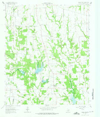
1962 Map of Miller Grove
USGS Topo · Published 1966About this map
Miller Grove and the surrounding agricultural landscapes of the Hunt Co Hopkins Co boundary are captured in this mid-century survey. The terrain is defined by a dense network of watercourses, including the Middle Fork, East Fork, and numerous smaller tributaries like Turkey Creek and Slough Creek. The presence of several water management structures, such as Dam No 12 and Dam No 13, indicates the era's focus on soil conservation and flood control in the Blackland Prairie and Post Oak Savannah transition zone.
Find a feature on this map
31 named features on this map. Tap any name to fly to it.
Don’t see what you’re looking for? This feature index may not catch every label — zoom into the map to look around manually.
Map Details
Editions of this 1962 Miller Grove Map
2 editions found
Other maps of this area

1953 · Texarkana
USGS Topo · 1:250,000

1956 · Texarkana
USGS Topo · 1:250,000

1956 · Tyler
USGS Topo · 1:250,000

1956 · Emory
USGS Topo · 1:62,500

1958 · Arbala
USGS Topo · 1:24,000

1959 · Alba
USGS Topo · 1:62,500

1962 · Lone Oak North
USGS Topo · 1:24,000

1962 · Brashear
USGS Topo · 1:24,000

1964 · Cumby
USGS Topo · 1:24,000

1964 · Commerce South
USGS Topo · 1:24,000