
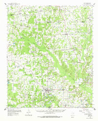
1959 Map of Alba
USGS Topo · Published 1961About this map
The Railroad corridors of East Texas define the mid-century landscape of this Wood County and Hopkins County border region. Small rural hubs like Alba and Yantis anchor a grid of family-owned farms and remote churches, reflecting a community structured around early petroleum development and agriculture. Local genealogists will find an incredible density of burial grounds and meeting houses, including Deaton Cem, Henry Chapel Cem, and Macedonia Ch. The map captures the industrial character of the era through the extensive Gas and Oil Field near Yantis and several pipelines that cut through the creek-fed lowlands. Significant water features like the Elm Fork and Shotgun Crossing Lake illustrate the complex hydrology of the Sabine River basin before major modern reservoir projects altered the local topography. This record documents many small settlements such as Ginger, Arbala, and Bright Star during their post-war development.
Find a feature on this map
90 named features on this map. Tap any name to fly to it.
Don’t see what you’re looking for? This feature index may not catch every label — zoom into the map to look around manually.
Map Details
Editions of this 1959 Alba Map
2 editions found
Other maps of this area

1953 · Texarkana
USGS Topo · 1:250,000

1956 · Texarkana
USGS Topo · 1:250,000

1956 · Tyler
USGS Topo · 1:250,000

1956 · Emory
USGS Topo · 1:62,500

1958 · Arbala
USGS Topo · 1:24,000

1958 · Alba
USGS Topo · 1:24,000

1959 · Calvary
USGS Topo · 1:24,000

1959 · Golden
USGS Topo · 1:24,000

1959 · Grand Saline
USGS Topo · 1:24,000

1959 · Yantis
USGS Topo · 1:24,000