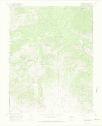
1967 Map of Klondike Mine
USGS Topo · Published 1970About this map
Rio Grande National Forest high country in Saguache County reveals a landscape shaped by mining and seasonal livestock grazing during the mid-1960s. The namesake Klondike Mine is situated centrally among the drainages of Sawlog Gulch and Findley Gulch, surrounded by numerous Prospects that indicate the area's geological promise. Settlement patterns are sparse and functional, represented by the Woodard Cow Camp and the enigmatically named Spook City near Bonita Creek. This high-elevation terrain is defined by water sources such as Cottonwood Spring, Alkali Spring, and Ute Spring, which were critical for the early range operations and mining camps. A network of unimproved dirt roads and a Jeep Trail provide the primary access through the steep drainages below Sheep Mountain and across Ute Pass.
Find a feature on this map
34 named features on this map. Tap any name to fly to it.
Don’t see what you’re looking for? This feature index may not catch every label — zoom into the map to look around manually.
Map Details
Editions of this 1967 Klondike Mine Map
3 editions found
Other maps of this area

1956 · Montrose
USGS Topo · 1:250,000

1959 · Montrose
USGS Topo · 1:250,000

1959 · Bonanza
USGS Topo · 1:62,500

1960 · Montrose
USGS Topo · 1:250,000
1967 · Laughlin Gulch
USGS Topo · 1:24,000

1967 · Lake Mountain NE
USGS Topo · 1:24,000

1967 · Chester
USGS Topo · 1:24,000
1967 · Klondike Mine
USGS Topo · 1:24,000
1967 · Hickey Bridge
USGS Topo · 1:24,000
1967 · Graveyard Gulch
USGS Topo · 1:24,000