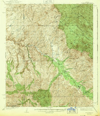
1943 Map of Klondyke
USGS Topo · Published 1943About this map
Klondyke and the surrounding mining districts of Graham and Pinal Counties appear here in a survey from the late 1930s. The settlement pattern follows the life-giving Aravaipa Creek, which cuts a prominent valley through the high desert. To the south, the Galiuro Mountains rise sharply, punctuated by peaks such as Mescal Peak and Black Butte. The map documents a rugged extractive economy, centering on the remote outpost of Copper Creek and a network of operations including the Grand Reef Mine, Glory Hole Mine, and Dog Water Mine. Local civic life is anchored by the Aravaipa Sch and the Aravaipa Ranger Station, while cattle ranching and land management are evident through the naming of various springs and the Landsman Camp within the Crook National Forest.
Find a feature on this map
51 named features on this map. Tap any name to fly to it.
Don’t see what you’re looking for? This feature index may not catch every label — zoom into the map to look around manually.
Map Details
Editions of this 1943 Klondyke Map
2 editions found
Other maps of this area

1911 · Winkelman
USGS Topo · 1:125,000

1913 · Winkelman
USGS Topo · 1:125,000

1915 · Christmas
USGS Topo · 1:62,500

1917 · Christmas
USGS Topo · 1:62,500

1938 · Galiuro Mts
USGS Topo · 1:48,000

1938 · Klondyke
USGS Topo · 1:48,000

1940 · Sierra Bonita Ranch
USGS Topo · 1:62,500

1942 · Sierra Bonita Ranch
USGS Topo · 1:62,500

1943 · Galiuro Mts
USGS Topo · 1:62,500

1943 · Klondyke
USGS Topo · 1:62,500