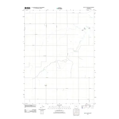
2012 Map of Klutz Canyon
USGS Topo · Published 2012About this map
Klutz Canyon and Box Elder Canyon cut through the high plains of Goshen County, creating a dramatic break in the otherwise steady expanse of Chugwater Flats. This landscape is defined by the winding course of Box Elder Cr and a rigid grid of rural roads that mirror the township and range survey system. To the northeast, Cedar Canyon joins the network of drainages, while the southwestern portion of the sheet is dominated by the level terrain of the flats.
Find a feature on this map
24 named features on this map. Tap any name to fly to it.
Don’t see what you’re looking for? This feature index may not catch every label — zoom into the map to look around manually.
Map Details
Editions of this 2012 Klutz Canyon Map
This is the sole edition of this map. No revisions or reprints were ever made.
Other maps of this area

1953 · Chugwater
USGS Topo · 1:24,000

1953 · Bordeaux
USGS Topo · 1:24,000

1954 · Cheyenne
USGS Topo · 1:250,000

1958 · Cheyenne
USGS Topo · 1:250,000

1962 · Bristol Ridge NE
USGS Topo · 1:24,000
1963 · Dickinson Hill
USGS Topo · 1:24,000

1963 · C S Ranch
USGS Topo · 1:24,000

1963 · Y B O Canyon
USGS Topo · 1:24,000

1963 · Klutz Canyon
USGS Topo · 1:24,000
1963 · Glomill Reservoir
USGS Topo · 1:24,000