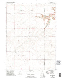
1990 Map of Klutz Canyon
USGS Topo · Published 1995About this map
Slater Flats and the high tablelands of southeastern Wyoming dominate this 1990s landscape, where the plateau is deeply incised by the drainage systems of Klutz Canyon and Box Elder Canyon. This topographical study reveals a sparsely populated ranching environment defined by wide expanses like Chugwater Flats and Center Flats. Human presence is concentrated near Eastwood and a solitary Cem in the southwest, suggesting the persistence of small rural hubs amidst the vast open range. The transition between the Platte and Goshen County line is marked by dramatic terrain shifts, particularly where Rusty Canyon and Cedar Canyon converge near the geological feature simply labeled Hole. The abundance of identified Springs and wells throughout these canyons indicates the critical importance of water management in this high-plains environment.
Find a feature on this map
15 named features on this map. Tap any name to fly to it.
Don’t see what you’re looking for? This feature index may not catch every label — zoom into the map to look around manually.
Map Details
Editions of this 1990 Klutz Canyon Map
This is the sole edition of this map. No revisions or reprints were ever made.
Other maps of this area

1953 · Chugwater
USGS Topo · 1:24,000

1953 · Bordeaux
USGS Topo · 1:24,000

1954 · Cheyenne
USGS Topo · 1:250,000

1958 · Cheyenne
USGS Topo · 1:250,000

1962 · Bristol Ridge NE
USGS Topo · 1:24,000
1963 · Dickinson Hill
USGS Topo · 1:24,000

1963 · C S Ranch
USGS Topo · 1:24,000

1963 · Y B O Canyon
USGS Topo · 1:24,000

1963 · Klutz Canyon
USGS Topo · 1:24,000
1963 · Glomill Reservoir
USGS Topo · 1:24,000