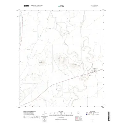
2019 Map of Knippa
USGS Topo · Published 2019About this map
The settlement of Knippa serves as the focal point for this survey of eastern Uvalde County, situated where the southern plains meet the rising Edwards Plateau. This area is defined by its complex drainage network, most notably the seasonal courses of the Dry Frio River and the Frio River, which carve winding paths through the landscape. The geography is punctuated by several prominent elevations that rise abruptly from the surrounding flats, including Blue Mtn, Black Mtn, and Big Mtn. These peaks likely owe their prominence to the volcanic activity suggested by the name Traprock Hill located just south of the town center. Local infrastructure is anchored by the corridor of US Highway 90 and a web of county roads that navigate between significant landmarks like Taylor Slough and Long Hollow. The map provides a clear picture of how water availability and terrain have shaped the agricultural and transport patterns in this part of Texas.
Find a feature on this map
33 named features on this map. Tap any name to fly to it.
Don’t see what you’re looking for? This feature index may not catch every label — zoom into the map to look around manually.
Map Details
Editions of this 2019 Knippa Map
This is the sole edition of this map. No revisions or reprints were ever made.
Other maps of this area

1898 · Uvalde
USGS Topo · 1:125,000

1899 · Uvalde
USGS Topo · 1:125,000

1954 · San Antonio
USGS Topo · 1:250,000

1957 · San Antonio
USGS Topo · 1:250,000

1960 · Concan
USGS Topo · 1:24,000
1969 · Trio
USGS Topo · 1:24,000
1971 · Sevenmile Hill
USGS Topo · 1:24,000
1971 · Garner Field NE
USGS Topo · 1:24,000
1971 · Garner Field
USGS Topo · 1:24,000
1971 · Uvalde
USGS Topo · 1:24,000