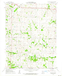
1961 Map of Knob Noster NW
USGS Topo · Published 1964About this map
The rolling agricultural borderlands of Lafayette and Johnson Counties are captured here during the early 1960s, defined by a sparse network of country roads and rural settlements. Small communities like Ernestville, Mount Olive, and Flagstaff anchor the landscape, while the Missouri Pacific railroad cuts through the northern section, following the subtle drainage of Davis. This area is characterized by several long-established rural institutions, including the Zion Hill Ch and Oak Grove Ch, as well as the New Hope Cem and Foster Cem, which provide significant anchor points for local genealogical research.
Find a feature on this map
20 named features on this map. Tap any name to fly to it.
Don’t see what you’re looking for? This feature index may not catch every label — zoom into the map to look around manually.
Map Details
Editions of this 1961 Knob Noster NW Map
2 editions found
Other maps of this area

1885 · Warrensburg
USGS Topo · 1:125,000

1887 · Warrensburg
USGS Topo · 1:125,000

1889 · Lexington
USGS Topo · 1:125,000

1894 · Warrensburg
USGS Topo · 1:125,000

1917 · Knobnoster
USGS Topo · 1:62,500

1947 · Jefferson City
USGS Topo · 1:250,000

1949 · Mayview
USGS Topo · 1:24,000

1950 · Mayview
USGS Topo · 1:24,000

1951 · Alma
USGS Topo · 1:24,000
1951 · Higginsville
USGS Topo · 1:24,000