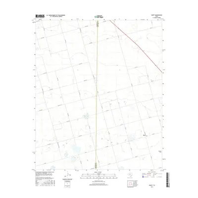
2016 Map of Knott
USGS Topo · Published 2016About this map
Knott serves as the primary hub of this High Plains landscape, situated at the intersection of a sprawling rural road network. The map reveals a strictly organized grid of county roads, such as Co RD 4300 and Co RD 4100, which overlay the terrain to support the region's agricultural and industrial layout. The natural topography is defined by subtle depressions and the presence of Buzzard Draw in the southeast corner. The survey also documents the geopolitical boundary between Martin Co and Howard Co, which bisects the quadrangle from north to south. This 2016 data captures the persistence of small West Texas communities and the vital role of farm-to-market roads like W FM 846 and FM 2230 in connecting these isolated pockets of activity.
Find a feature on this map
36 named features on this map. Tap any name to fly to it.
Don’t see what you’re looking for? This feature index may not catch every label — zoom into the map to look around manually.
Map Details
Editions of this 2016 Knott Map
This is the sole edition of this map. No revisions or reprints were ever made.
Other maps of this area

1954 · Big Spring
USGS Topo · 1:250,000

1958 · Big Spring
USGS Topo · 1:250,000

1966 · Knott
USGS Topo · 1:24,000

1966 · Merrick
USGS Topo · 1:24,000

1966 · Knott SE
USGS Topo · 1:24,000

1966 · Knott SW
USGS Topo · 1:24,000
1966 · Lenorah East
USGS Topo · 1:24,000

1966 · Knott NE
USGS Topo · 1:24,000

1970 · Vealmoor
USGS Topo · 1:24,000

1970 · Ackerly
USGS Topo · 1:24,000