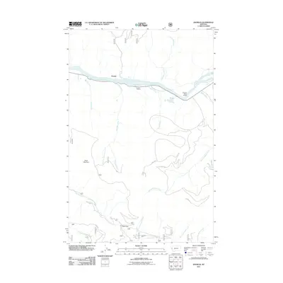
2011 Map of Knowles
USGS Topo · Published 2011About this map
The Flathead River carves a deep path through the center of this landscape, serving as the primary geographic anchor for the settlement of Knowles. This 2011 survey reveals a complex drainage network where numerous tributaries, such as Wilson Creek and Burgess Creek, descend from the surrounding high ground to join the main river. The built environment is sparse, centered on the Flathead River Bridge and the small Gingery Cemetery nearby, reflecting a quiet rural character.
Find a feature on this map
26 named features on this map. Tap any name to fly to it.
Don’t see what you’re looking for? This feature index may not catch every label — zoom into the map to look around manually.
Map Details
Editions of this 2011 Knowles Map
This is the sole edition of this map. No revisions or reprints were ever made.
Other maps of this area
1956 · Wallace
USGS Topo · 1:250,000
1959 · Tarkio
USGS Topo · 1:62,500
1959 · Perma
USGS Topo · 1:62,500
1959 · Plains
USGS Topo · 1:62,500
1960 · Wallace
USGS Topo · 1:250,000
1960 · Superior
USGS Topo · 1:62,500
1983 · Horsehead Peak
USGS Topo · 1:24,000
1984 · Stark North
USGS Topo · 1:24,000
1984 · Paradise
USGS Topo · 1:24,000
1984 · Sunrise Spring
USGS Topo · 1:24,000