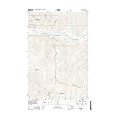
2014 Map of Knowles
USGS Topo · Published 2014About this map
The Flathead River carves a deep valley through the heart of the Lolo National Forest, serving as a primary corridor for both transportation and drainage. The small settlement of Knowles sits along the northern bank, linked to the southern ridges by the Flathead River Bridge and MT-200. The terrain is defined by dramatic elevation changes, rising from the river bottoms to high points like Siegel Mtn and the transit point at Siegel Pass. Genealogy and local history researchers will find the Gingery Cem located just south of the river near Burgess Cr. The map documents a complex network of forest roads and trails, such as the Ninemile-Siegle Rd, which provide access to secluded water bodies like Burgess Lake and numerous mountain drainages including Robertson Cr and Wilson Cr.
Find a feature on this map
29 named features on this map. Tap any name to fly to it.
Don’t see what you’re looking for? This feature index may not catch every label — zoom into the map to look around manually.
Map Details
Editions of this 2014 Knowles Map
This is the sole edition of this map. No revisions or reprints were ever made.
Other maps of this area

1956 · Wallace
USGS Topo · 1:250,000

1959 · Tarkio
USGS Topo · 1:62,500

1959 · Perma
USGS Topo · 1:62,500

1959 · Plains
USGS Topo · 1:62,500

1960 · Wallace
USGS Topo · 1:250,000

1960 · Superior
USGS Topo · 1:62,500

1983 · Horsehead Peak
USGS Topo · 1:24,000

1984 · Stark North
USGS Topo · 1:24,000
1984 · Paradise
USGS Topo · 1:24,000
1984 · Sunrise Spring
USGS Topo · 1:24,000