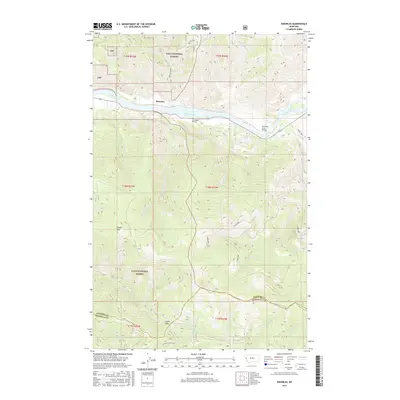
2017 Map of Knowles
USGS Topo · Published 2017About this map
The Flathead River cuts a wide path through this portion of the Lolo National Forest in western Montana, defining the local geography near the settlement of Knowles. Much of the terrain is dominated by significant elevations such as Siegel Mtn and the strategic Siegel Pass to the south. The area’s hydrology is defined by a dense network of mountain streams including Knowles Creek, Robertson Cr, and Saint Louis Cr, which drain the timbered slopes. Evidence of early 20th-century settlement and transit is found in the Gingery Cem located south of the river and the Flathead River Bridge. A series of forest roads, including Dixon 2000 and Ninemile-Siegle Rd 7, provide the primary access through this steep landscape, which spans the border of Sanders and Missoula Counties.
Find a feature on this map
35 named features on this map. Tap any name to fly to it.
Don’t see what you’re looking for? This feature index may not catch every label — zoom into the map to look around manually.
Map Details
Editions of this 2017 Knowles Map
This is the sole edition of this map. No revisions or reprints were ever made.
Other maps of this area

1956 · Wallace
USGS Topo · 1:250,000

1959 · Tarkio
USGS Topo · 1:62,500

1959 · Perma
USGS Topo · 1:62,500

1959 · Plains
USGS Topo · 1:62,500

1960 · Wallace
USGS Topo · 1:250,000

1960 · Superior
USGS Topo · 1:62,500

1983 · Horsehead Peak
USGS Topo · 1:24,000

1984 · Stark North
USGS Topo · 1:24,000
1984 · Paradise
USGS Topo · 1:24,000
1984 · Sunrise Spring
USGS Topo · 1:24,000