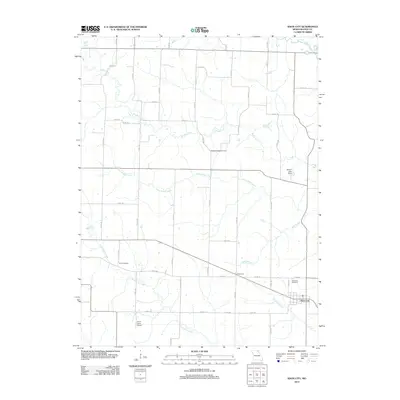
2012 Map of Knox City
USGS Topo · Published 2012About this map
Knox City serves as the primary hub in this corner of Northeast Missouri, situated at the junction of several rural routes including those leading to the Knox City Cemetery and south toward the Joe D Lewis Airport. The landscape is defined by the winding paths of the Middle Fabius River in the north and the extensive reach of Troublesome Creek to the south. This survey reveals a community deeply tied to its small drainage networks, where the small settlement of Buttermilk rests along the upper reaches of Wolf Branch. Genealogists will find interest in several local burial sites, including the Davis Cemetery and Pleasant Ridge Cemetery, which are scattered throughout the agricultural tracts north of the city. The presence of Wilson Lake Dam on a tributary of Little Bridge Creek illustrates the local water management common to this prairie-and-creek terrain.
Find a feature on this map
61 named features on this map. Tap any name to fly to it.
Don’t see what you’re looking for? This feature index may not catch every label — zoom into the map to look around manually.
Map Details
Editions of this 2012 Knox City Map
This is the sole edition of this map. No revisions or reprints were ever made.
Other maps of this area

1903 · Kahoka
USGS Topo · 1:125,000

1903 · Edina
USGS Topo · 1:125,000

1950 · Colony
USGS Topo · 1:24,000

1950 · La Belle
USGS Topo · 1:24,000

1951 · La Belle
USGS Topo · 1:24,000

1951 · Colony
USGS Topo · 1:24,000
1951 · Deer Ridge
USGS Topo · 1:24,000

1954 · Centerville
USGS Topo · 1:250,000

1957 · Centerville
USGS Topo · 1:250,000

1958 · Centerville
USGS Topo · 1:250,000