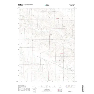
2017 Map of Knox City
USGS Topo · Published 2017About this map
Knox City serves as the primary hub for this section of Missouri, characterized by a regular grid of county roads and agricultural land. The landscape is defined by the drainage systems of Bridge Cr and Little Bridge Cr in the north, while the southern portion is marked by the winding paths of Troublesome Cr and Little Troublesome Cr. These waterways create a undulating topography that dictates the placement of rural cemeteries and homesteads. Local history and genealogy are preserved at the Knox City Cem, East Pleasant Ridge Cem, and Davis Cem. A small body of water, Wilson Lake, provides a distinct landmark amidst the network of thoroughfares like State Hwy AA and State Hwy V. The map reveals a transition from the structured town layout of Knox City to the surrounding rural sections of t62n r10w and t63n r11w.
Find a feature on this map
73 named features on this map. Tap any name to fly to it.
Don’t see what you’re looking for? This feature index may not catch every label — zoom into the map to look around manually.
Map Details
Editions of this 2017 Knox City Map
This is the sole edition of this map. No revisions or reprints were ever made.
Other maps of this area

1903 · Kahoka
USGS Topo · 1:125,000

1903 · Edina
USGS Topo · 1:125,000

1950 · Colony
USGS Topo · 1:24,000

1950 · La Belle
USGS Topo · 1:24,000

1951 · La Belle
USGS Topo · 1:24,000

1951 · Colony
USGS Topo · 1:24,000
1951 · Deer Ridge
USGS Topo · 1:24,000

1954 · Centerville
USGS Topo · 1:250,000

1957 · Centerville
USGS Topo · 1:250,000

1958 · Centerville
USGS Topo · 1:250,000