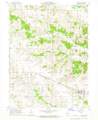
1965 Map of Knox City
USGS Topo · Published 1966About this map
Knox City, also known as Knox Station, serves as the primary hub for this rural portion of Knox County during the mid-1960s. The town is situated along the Chicago Burlington and Quincy railroad, which cuts a straight path through the southern half of the map. This rail line is the defining piece of infrastructure for the area, connecting local agriculture to wider markets. The landscape is characterized by a series of branching waterways, including Troublesome Creek and Bridge Creek, which carve through the townships of Benton, Colony, Liberty, and Myrtle.
Find a feature on this map
19 named features on this map. Tap any name to fly to it.
Don’t see what you’re looking for? This feature index may not catch every label — zoom into the map to look around manually.
Map Details
Editions of this 1965 Knox City Map
This is the sole edition of this map. No revisions or reprints were ever made.
Other maps of this area

1903 · Kahoka
USGS Topo · 1:125,000

1903 · Edina
USGS Topo · 1:125,000

1950 · Colony
USGS Topo · 1:24,000

1950 · La Belle
USGS Topo · 1:24,000

1951 · La Belle
USGS Topo · 1:24,000

1951 · Colony
USGS Topo · 1:24,000
1951 · Deer Ridge
USGS Topo · 1:24,000

1954 · Centerville
USGS Topo · 1:250,000

1957 · Centerville
USGS Topo · 1:250,000

1958 · Centerville
USGS Topo · 1:250,000