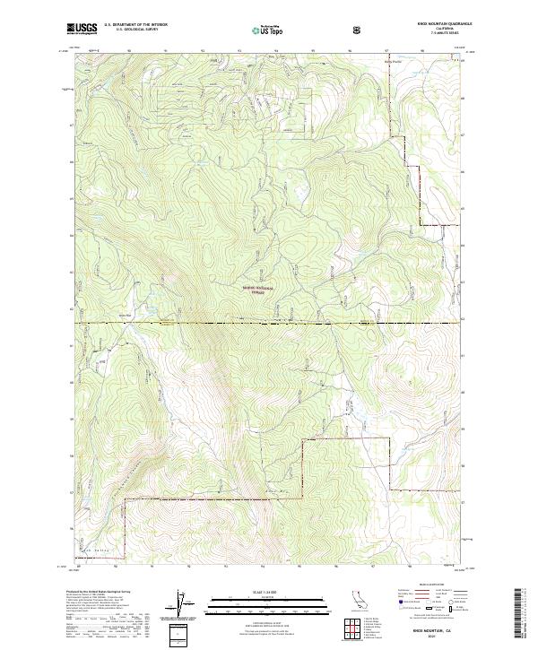
2021 Map of Knox Mountain
USGS Topo · Published 2021About this map
The high-elevation terrain of Modoc National Forest spans the border between Modoc and Lassen counties, centered on the prominent rise of Knox Mtn. This landscape is defined by its complex hydrology, with numerous named water sources such as Salt Log Spring, Big John Spring, and the remote Comfort Cabin Spring supporting local activity in an otherwise arid environment. The map details the transition from the broad expanse of Knox Flat into the deepening recesses of Cottonwood Canyon, where Cottonwood Cr begins its descent. To the south, the terrain opens into Ash Valley, a distinct geographical break from the forested uplands. The presence of specialized sites like Indian Springs and Rocky Prairie suggests a landscape historically utilized for seasonal grazing and resource management within the forest boundaries.
Find a feature on this map
22 named features on this map. Tap any name to fly to it.
Don’t see what you’re looking for? This feature index may not catch every label — zoom into the map to look around manually.
Map Details
Editions of this 2021 Knox Mountain Map
This is the sole edition of this map. No revisions or reprints were ever made.
Other maps of this area

1886 · Alturas
USGS Topo · 1:250,000

1892 · Alturas
USGS Topo · 1:250,000

1954 · Alturas
USGS Topo · 1:250,000

1958 · Alturas
USGS Topo · 1:250,000

1961 · Canby
USGS Topo · 1:62,500

1961 · Alturas
USGS Topo · 1:62,500

1962 · Alturas
USGS Topo · 1:250,000
1962 · Adin
USGS Topo · 1:62,500

1962 · Likely
USGS Topo · 1:62,500

1965 · Alturas
USGS Topo · 1:250,000