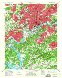
1966 Map of Knoxville
USGS Topo · Published 1968About this map
Knoxville serves as the focal point of this mid-century urban landscape, captured just as the modern interstate system was reshaping its geography. The city center is densely detailed with public landmarks including the Courthouse, City Hall, and the sprawling University of Tennessee campus along the Tennessee River. The transit infrastructure of the era is clearly visible, showing the Southern Railway and Louisville And Nashville Railroad corridors competing for space with newly constructed segments of Interstate 40 and Interstate 75.
Find a feature on this map
116 named features on this map. Tap any name to fly to it.
Don’t see what you’re looking for? This feature index may not catch every label — zoom into the map to look around manually.
Map Details
Editions of this 1966 Knoxville Map
2 editions found
Other maps of this area

1886 · Knoxville
USGS Topo · 1:125,000

1892 · Knoxville
USGS Topo · 1:125,000

1893 · Briceville
USGS Topo · 1:125,000

1894 · Knoxville
USGS Topo · 1:125,000

1895 · Loudon
USGS Topo · 1:125,000

1895 · Briceville
USGS Topo · 1:125,000

1895 · Knoxville
USGS Topo · 1:125,000

1896 · Briceville
USGS Topo · 1:125,000

1897 · Maynardville
USGS Topo · 1:125,000

1900 · Maynardville
USGS Topo · 1:125,000