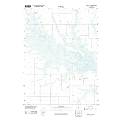
2010 Map of Knoxville NW
USGS Topo · Published 2010About this map
Lake Red Rock dominates the central landscape of this Marion County corridor, where the Des Moines River meanders through expansive wetlands and floodplains. The small settlement of Dunreath sits just north of the water, a focal point for local history alongside several family and community burial grounds that dot the surrounding uplands. These sites, including Pleasant Hill Cemetery, Hughes Cemetery, and Dunreath Cemetery, provide critical anchors for genealogical research in this rural township. The terrain is defined by a dense network of tributaries like Wildcat Creek, Prairie Creek, and North Wildcat Creek that drain into the reservoir. South of the river, the landscape transitions into a grid of agricultural roads, including Co Hwy G40 and Co Hwy S45, which connect isolated farmsteads and smaller landmarks such as Burch Cemetery and Schirey Cemetery.
Find a feature on this map
30 named features on this map. Tap any name to fly to it.
Don’t see what you’re looking for? This feature index may not catch every label — zoom into the map to look around manually.
Map Details
Editions of this 2010 Knoxville NW Map
This is the sole edition of this map. No revisions or reprints were ever made.
Other maps of this area

1909 · Knoxville
USGS Topo · 1:62,500

1910 · Milo
USGS Topo · 1:62,500

1912 · Knoxville
USGS Topo · 1:62,500

1930 · Mitchellville
USGS Topo · 1:62,500

1954 · Des Moines
USGS Topo · 1:250,000

1956 · Des Moines
USGS Topo · 1:250,000

1957 · Des Moines
USGS Topo · 1:250,000

1965 · Pleasantville
USGS Topo · 1:24,000

1965 · Prairie City
USGS Topo · 1:24,000

1965 · Knoxville NW
USGS Topo · 1:24,000
Featured Places
- Knoxville Township, IA
- Union Township, IA
- Red Rock Township, IA
- Pleasant Grove Township, IA
- Marion County, IA