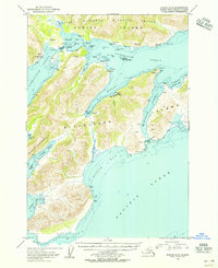
1954 Map of Kodiak A-4
USGS Topo · Published 1955About this map
Old Harbor serves as the primary coastal settlement on the southern reaches of Kodiak Island, situated where the mountains meet the deep waters of Sitkalidak Strait. This mid-century survey illustrates a landscape defined by maritime industry and subsistence, most notably at the Whaling Sta (Aban'd) near Port Hobron. The proximity of the Old Harbor Cem to the town site offers a localized point of interest for genealogists tracing families in this part of the Kodiak National Wildlife Refuge. Beyond the town, the coastline is deeply indented by fjords and inlets like Amee Bay and Natalia Bay, while Sitkalidak Island provides a protective barrier against the open Pacific Ocean. The presence of several Cabins scattered along McDonald Lagoon and Tanginak Anchorage suggests a seasonal pattern of hunting and fishing typical of the era.
Find a feature on this map
52 named features on this map. Tap any name to fly to it.
Don’t see what you’re looking for? This feature index may not catch every label — zoom into the map to look around manually.
Map Details
Editions of this 1954 Kodiak A-4 Map
This is the sole edition of this map. No revisions or reprints were ever made.
Other maps of this area

1949 · Kodiak A-3
USGS Topo · 1:63,360

1949 · Kodiak B-3
USGS Topo · 1:63,360

1950 · Kodiak A-3
USGS Topo · 1:63,360

1950 · Kodiak B-3
USGS Topo · 1:63,360

1951 · Kaguyak
USGS Topo · 1:250,000

1952 · Kodiak
USGS Topo · 1:250,000

1952 · Kaguyak
USGS Topo · 1:250,000

1952 · Kaguyak D-5
USGS Topo · 1:63,360

1952 · Kodiak B-5
USGS Topo · 1:63,360

1952 · Kodiak B-4
USGS Topo · 1:63,360