
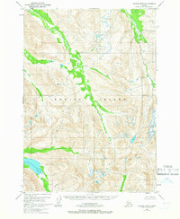
1952 Map of Kodiak B-5
USGS Topo · Published 1966About this map
Kodiak Island is characterized by its dramatic topographic relief and intricate network of glacial valleys and mountain ridges. The entire land area shown on this sheet is contained within the Kodiak National Wildlife Refuge, which was established to protect the habitat of the Kodiak brown bear. The map illustrates a primitive and unpopulated landscape, devoid of roads or trails, as it appeared in the early 1950s. The heavy contour lines reveal deep alpine cirques and steep-walled valleys that drain toward the coast, though the coastline itself remains just out of view. This survey was conducted before significant modern infrastructure reached these interior portions of the refuge, providing a clear record of the terrain as seen by the Bureau of Land Management and the U.S. Geological Survey during their mid-century mapping efforts.
Find a feature on this map
2 named features on this map. Tap any name to fly to it.
Don’t see what you’re looking for? This feature index may not catch every label — zoom into the map to look around manually.
Map Details
Editions of this 1952 Kodiak B-5 Map
2 editions found
Other maps of this area

1952 · Kodiak
USGS Topo · 1:250,000

1952 · Kodiak B-6
USGS Topo · 1:63,360

1952 · Kodiak C-4
USGS Topo · 1:63,360

1952 · Kodiak C-5
USGS Topo · 1:63,360

1952 · Kodiak C-6
USGS Topo · 1:63,360

1952 · Kodiak B-4
USGS Topo · 1:63,360

1952 · Kodiak A-6
USGS Topo · 1:63,360
1952 · Kodiak A-5
USGS Topo · 1:63,360
1952 · Kodiak A-4
USGS Topo · 1:63,360
1954 · Kodiak C-6
USGS Topo · 1:63,360