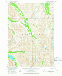
1952 Map of Kodiak B-5
USGS Topo · Published 1972About this map
The interior wilds of Kodiak Island are documented here through the lens of a mid-century aerial survey. In an area where no roads or trails are noted on the sheet, the geography is defined entirely by the intricate drainage basins and high ridgelines that characterize the archipelago's spine. The entire land area shown is designated as the Kodiak National Wildlife Refuge, highlighting a landscape managed for conservation rather than settlement. While the interior remains uninhabited, the presence of depth curves in the surrounding waters—compiled from early 1950s hydrographic charts—points to the coastal focus of the region's economy and navigation. This survey represents a period when federal agencies like the Bureau of Land Management and the Geological Survey were formalizing the boundaries of these protected Alaskan territories.
Find a feature on this map
2 named features on this map. Tap any name to fly to it.
Don’t see what you’re looking for? This feature index may not catch every label — zoom into the map to look around manually.
Map Details
Editions of this 1952 Kodiak B-5 Map
2 editions found
Other maps of this area

1952 · Kodiak
USGS Topo · 1:250,000

1952 · Kodiak B-6
USGS Topo · 1:63,360

1952 · Kodiak C-4
USGS Topo · 1:63,360

1952 · Kodiak C-5
USGS Topo · 1:63,360

1952 · Kodiak B-5
USGS Topo · 1:63,360

1952 · Kodiak C-6
USGS Topo · 1:63,360

1952 · Kodiak B-4
USGS Topo · 1:63,360

1952 · Kodiak A-6
USGS Topo · 1:63,360
1952 · Kodiak A-5
USGS Topo · 1:63,360
1952 · Kodiak A-4
USGS Topo · 1:63,360