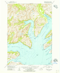
1954 Map of Kodiak A-5
USGS Topo · Published 1955About this map
Nunamiut (Aban'd) sits on the western shore of Three Saints Bay, marking a significant point of human history on the southeastern coast of Kodiak Island. This mid-century survey reveals a maritime-oriented landscape where the deep indentations of Barling Bay and Kaiugnak Bay define the shoreline. The topography is largely contained within the Kodiak National Wildlife Refuge, emphasizing the preserved character of the terrain. Across the Sitkalidak Strait, the northern portion of Sitkalidak Island is visible, including the Natalia Peninsula and Newman Bay. Navigation features such as Tallapoosa Shoal and John Island highlight the importance of coastal waters, while the southern reaches open into the broad expanse of Rolling Bay. The map provides a detailed view of the complex hydrology, from the small Annulu Creek to the various unnamed glacial lakes and high-elevation peaks that dominate the island's interior.
Find a feature on this map
20 named features on this map. Tap any name to fly to it.
Don’t see what you’re looking for? This feature index may not catch every label — zoom into the map to look around manually.
Map Details
Editions of this 1954 Kodiak A-5 Map
This is the sole edition of this map. No revisions or reprints were ever made.
Other maps of this area

1951 · Kaguyak
USGS Topo · 1:250,000

1952 · Kodiak
USGS Topo · 1:250,000

1952 · Kaguyak
USGS Topo · 1:250,000

1952 · Kodiak B-6
USGS Topo · 1:63,360

1952 · Kaguyak D-5
USGS Topo · 1:63,360

1952 · Kodiak B-5
USGS Topo · 1:63,360

1952 · Kaguyak D-6
USGS Topo · 1:63,360

1952 · Kodiak B-4
USGS Topo · 1:63,360

1952 · Kodiak A-6
USGS Topo · 1:63,360
1952 · Kodiak A-5
USGS Topo · 1:63,360