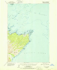
1951 Map of Kodiak C-1
USGS Topo · Published 1951About this map
The northeastern coastline of Kodiak Island meets the Gulf of Alaska in this 1951 topographic study, centered on the strategic point at Cape Chiniak. The map documents a rugged landscape where the interior heights of Boyer Peak and Slope Peak drop toward the complex shorelines of Chiniak Bay and Isthmus Bay. Of particular interest to researchers is the inclusion of the Airstrip near Chiniak Pt, reflecting mid-century maritime and aerial navigation infrastructure. Offshore, the survey details navigational hazards such as Kalsin Reef and Humpback Rock, while the southern portion of the sheet is defined by the drainage of the Sacramento River as it flows toward the Pacific Ocean. This edition captures the topography of the island's eastern reach before modern development altered the coastal character of these judicial division lands.
Find a feature on this map
25 named features on this map. Tap any name to fly to it.
Don’t see what you’re looking for? This feature index may not catch every label — zoom into the map to look around manually.
Map Details
Editions of this 1951 Kodiak C-1 Map
2 editions found
Other maps of this area

1949 · Kodiak C-2
USGS Topo · 1:63,360

1949 · Kodiak B-1 and B-2
USGS Topo · 1:63,360

1949 · Kodiak D-2
USGS Topo · 1:63,360

1949 · Kodiak C-1
USGS Topo · 1:63,360

1949 · Kodiak D-1
USGS Topo · 1:63,360

1951 · Kodiak D-1
USGS Topo · 1:63,360

1951 · Kodiak B-1 and B-2
USGS Topo · 1:63,360

1951 · Kodiak D-2
USGS Topo · 1:63,360

1951 · Kodiak C-1
USGS Topo · 1:63,360

1952 · Kodiak
USGS Topo · 1:250,000