
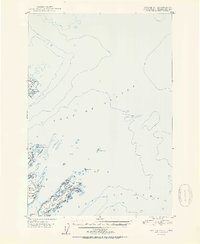
1951 Map of Kodiak D-1
USGS Topo · Published 1951About this map
The maritime landscape of the Gulf of Alaska and the Pacific Ocean dominates this coastal study, centering on the islands and treacherous waters just east of Kodiak. Woody Island and Long Island serve as the primary landmasses, featuring established landmarks such as the Radio Towers and Elephant Lake. The presence of Hamin Rocks Light and Williams Reef highlights the navigation hazards of this era, while the inland Hutchinson Road provides a glimpse into the early transportation network connecting the coastline.
Find a feature on this map
24 named features on this map. Tap any name to fly to it.
Don’t see what you’re looking for? This feature index may not catch every label — zoom into the map to look around manually.
Map Details
Editions of this 1951 Kodiak D-1 Map
2 editions found
Other maps of this area

1949 · Kodiak C-2
USGS Topo · 1:63,360

1949 · Kodiak D-2
USGS Topo · 1:63,360

1949 · Kodiak C-1
USGS Topo · 1:63,360

1949 · Kodiak D-1
USGS Topo · 1:63,360

1951 · Kodiak D-2
USGS Topo · 1:63,360

1951 · Kodiak C-1
USGS Topo · 1:63,360

1952 · Kodiak
USGS Topo · 1:250,000

1952 · Afognak
USGS Topo · 1:250,000

1952 · Afognak A-1
USGS Topo · 1:63,360

1952 · Afognak A-2
USGS Topo · 1:63,360