
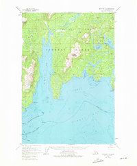
1952 Map of Afognak A-2
USGS Topo · Published 1967About this map
Afognak Island reveals a landscape of deep fjords and maritime industry within the Chugach National Forest during the mid-twentieth century. The map highlights the coastal geography of the Kodiak Archipelago, where protected waters like Kazakof Bay and Duck Bay meet the open waters of Marmot Bay. A focal point of local activity is the hatchery situated on Kitoi Bay, supported by the freshwater systems of Big Kitoi Lake and Little Kitoi Lake.
Find a feature on this map
29 named features on this map. Tap any name to fly to it.
Don’t see what you’re looking for? This feature index may not catch every label — zoom into the map to look around manually.
Map Details
Editions of this 1952 Afognak A-2 Map
2 editions found
Other maps of this area

1947 · Kodiak D-3
USGS Topo · 1:63,360

1949 · Kodiak D-2
USGS Topo · 1:63,360

1949 · Kodiak D-3
USGS Topo · 1:63,360

1949 · Kodiak D-1
USGS Topo · 1:63,360

1950 · Kodiak D-3
USGS Topo · 1:63,360

1951 · Kodiak D-1
USGS Topo · 1:63,360

1951 · Kodiak D-2
USGS Topo · 1:63,360

1952 · Kodiak
USGS Topo · 1:250,000

1952 · Afognak
USGS Topo · 1:250,000

1952 · Afognak A-3
USGS Topo · 1:63,360