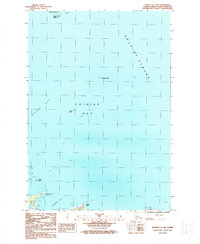
1987 Map of Kodiak C-1 NW
USGS Topo · Published 1988About this map
The coast of Long Island and the intricate waters of Chiniak Bay define this 1980s coastal survey. The map details a maritime landscape where the Gulf of Alaska meets specialized landforms such as Isthmus Point and Midway Point. These features indicate the complex navigational environment of the Kodiak Archipelago, where numerous unnamed rocks and reefs, such as Kalsin Reef, posed significant challenges to maritime traffic.
Find a feature on this map
18 named features on this map. Tap any name to fly to it.
Don’t see what you’re looking for? This feature index may not catch every label — zoom into the map to look around manually.
Map Details
Editions of this 1987 Kodiak C-1 NW Map
This is the sole edition of this map. No revisions or reprints were ever made.
Other maps of this area

1949 · Kodiak C-2
USGS Topo · 1:63,360

1949 · Kodiak D-2
USGS Topo · 1:63,360

1949 · Kodiak C-1
USGS Topo · 1:63,360

1949 · Kodiak D-1
USGS Topo · 1:63,360

1951 · Kodiak D-1
USGS Topo · 1:63,360

1951 · Kodiak D-2
USGS Topo · 1:63,360

1951 · Kodiak C-1
USGS Topo · 1:63,360

1952 · Kodiak
USGS Topo · 1:250,000
1987 · Kodiak C-1 SW
USGS Topo · 1:25,000
1987 · Kodiak D-1 SW
USGS Topo · 1:25,000