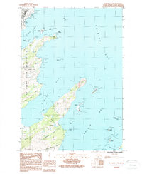
1987 Map of Kodiak C-2 NE
USGS Topo · Published 1988About this map
US Coast Guard Reservation land dominates the western edge of this 1980s coastal study, bordering the complex maritime infrastructure of Kodiak Airport. The terrain transitions from the elevations of Zaimka Ridge down to a series of deeply recessed inlets, including Womens Bay, Middle Bay, and Kalsin Bay. This provisional survey reflects the logistical importance of the area, where the Kodiak Island Highway provides a critical overland link between coastal landmarks like Cliff Point and the interior drainage of Mayflower Creek. Numerous small islands and rocky hazards, such as Queer Island and Viesoki Island, are meticulously positioned within the larger expanse of Chiniak Bay. Freshwater features like Snag Lake and Dragonfly Lake sit just inland from the shoreline, illustrating the immediate shift from marine to alpine environments characteristic of this part of the island.
Find a feature on this map
32 named features on this map. Tap any name to fly to it.
Don’t see what you’re looking for? This feature index may not catch every label — zoom into the map to look around manually.
Map Details
Editions of this 1987 Kodiak C-2 NE Map
This is the sole edition of this map. No revisions or reprints were ever made.
Other maps of this area

1949 · Kodiak C-2
USGS Topo · 1:63,360

1949 · Kodiak D-2
USGS Topo · 1:63,360

1949 · Kodiak C-1
USGS Topo · 1:63,360

1949 · Kodiak D-1
USGS Topo · 1:63,360

1951 · Kodiak D-1
USGS Topo · 1:63,360

1951 · Kodiak D-2
USGS Topo · 1:63,360

1951 · Kodiak C-1
USGS Topo · 1:63,360

1952 · Kodiak
USGS Topo · 1:250,000
1987 · Kodiak C-1 SW
USGS Topo · 1:25,000
1987 · Kodiak D-1 SW
USGS Topo · 1:25,000