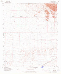
1965 Map of Kofa
USGS Topo · Published 1966About this map
Yuma Proving Ground dominates this 1965 survey, illustrating a desert landscape defined by military utility and topographic isolation. The Southern Pacific railroad line cuts across the southern portion of the quadrangle, serving as a primary transit corridor near the small settlement of Kofa. The terrain transitions from the stark elevation of the Palomas Mts in the northeast to broad alluvial plains marked by several wells and a Water Tank. A network of unimproved dirt roads and a Jeep Trail provide the only access through this arid environment, highlighting the area's sparse development during the mid-1960s. This survey records the intersection of high-desert geography with the technical requirements of the Department of the Interior and military infrastructure at the height of the Cold War era.
Find a feature on this map
17 named features on this map. Tap any name to fly to it.
Don’t see what you’re looking for? This feature index may not catch every label — zoom into the map to look around manually.
Map Details
Editions of this 1965 Kofa Map
3 editions found
Other maps of this area

1928 · Norton
USGS Topo · 1:62,500

1929 · Norton
USGS Topo · 1:62,500

1930 · Stoval
USGS Topo · 1:62,500

1942 · Vicksburg
USGS Topo · 1:250,000

1950 · Stoval
USGS Topo · 1:62,500

1953 · Ajo
USGS Topo · 1:250,000

1954 · Phoenix
USGS Topo · 1:250,000

1955 · Growler
USGS Topo · 1:24,000

1955 · Roll
USGS Topo · 1:62,500

1957 · Ajo
USGS Topo · 1:250,000