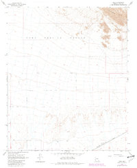
1965 Map of Kofa
USGS Topo · Published 1982About this map
Southern Pacific railroad tracks cut across the arid southwestern corner of this desert landscape, providing a vital transportation link near the settlement of Kofa. The terrain is dominated by the expansive Yuma Proving Ground, which covers a significant portion of the northern and central sections of the quadrangle. This military reservation, established for equipment testing in the desert environment, is characterized here by wide alluvial plains that lead toward the high ground of the Palomas Mts in the northeast. Water resources are scarce in this environment, with only a few mapped features such as a Well and a Water Tank located near the rail line. A network of unimproved roads and a Jeep Trail provide the only access through the open territory between the mountains and the railroad siding.
Find a feature on this map
20 named features on this map. Tap any name to fly to it.
Don’t see what you’re looking for? This feature index may not catch every label — zoom into the map to look around manually.
Map Details
Editions of this 1965 Kofa Map
3 editions found
Other maps of this area

1928 · Norton
USGS Topo · 1:62,500

1929 · Norton
USGS Topo · 1:62,500

1930 · Stoval
USGS Topo · 1:62,500

1942 · Vicksburg
USGS Topo · 1:250,000

1950 · Stoval
USGS Topo · 1:62,500

1953 · Ajo
USGS Topo · 1:250,000

1954 · Phoenix
USGS Topo · 1:250,000

1955 · Growler
USGS Topo · 1:24,000

1955 · Roll
USGS Topo · 1:62,500

1957 · Ajo
USGS Topo · 1:250,000